Day 3: Climate Part I—Introduction To Climatic Factors
Dear Student,
The climate you live in has a major impact on your self-sufficiency plans. It’s such a critical consideration, that I’m devoting two full lessons on planning for it, so stay tuned for more on climate tomorrow.
How you position and build your home, what materials you use…
Where, what, and when you plant…
How you harvest and store your water supply…
These are all intrinsically linked to your climate profile.
You may think this unimportant for just a small backyard operation, but homesteaders big and small must assess their climate before planning.
There are three broad climate zones and seven minor climate profiles worldwide. Depending on where you’re located, you may fall squarely into one of the profiles, but there may be more than one climatic influence over your region.
But there are several other effects beyond simple regional climate that will also need to be considered for you to determine your homestead’s “true climate,” as it were. Aside from regional climates, you’ve got to take into account mitigating factors like wind, altitude, maritime or continental effects, rain shadows, and microclimates.
I’ll explain below…
Major Climate Zones
Temperate Climates
- Polar: cool to cold and humid; deep snow
- Cold temperate: very long days in summer, deep snows in winter
- Cool temperate: light snow in winter
- Warm temperate: rare snow
- Mediterranean climate: no snow
Precipitation: winter wet; summer dry
Characteristics: Deep soils with 60% of the biomass (trees and plants) above the soil and 40% in the soil. Animals live in the ground. Large amounts of herbs and deciduous leaves. Light is gentle, with long summer days. This is the most stable zone for growing, with growth periods in spring and summer; all growth dormant in winter.
Tropical Climates
- Humid subtropics: southeast side of all continents, between latitudes 25° and 35°
- Wet and dry tropics: closer to the equator
- Wet tropics: closer again to the equator
- Equatorial tropics: within 6 degrees of the equator; two rainy seasons
- Dry tropics: inside the tropical region but in drylands
Precipitation: winter dry; summer wet.
Characteristics: Shallow soils with all nutrients on the thin top layer of soil, the rest is subsoil. Biomass is 90% above ground. Animals don’t burrow due to the risk of drowning; few earthworms here for this reason also. Woody growth year-round, only slowing in the dry season. Decomposition is super-fast. There is great potential for aquaculture here.
Dryland Climates
- Dry sub-humid lands
- Semi-arid lands
- Arid lands
- Hyper-arid lands
Precipitation: minimal
Characteristics: Water (or lack thereof) is the major issue here. Soils can be of good depth and fertility. Water harvesting and conservation is necessary here. Shade must be created for plants, animals, and our homes. The housing may even be underground for cooling effects. Erosion can be caused by wind and floods, decomposition from termites, ants, macrofauna, and fungi.
Wind Patterns
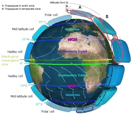
Wind transports heat away from equatorial regions and brings cooler air from the poles to the tropics. Wind circulation consists of three cells: the Hadley (equatorial), Ferrel (mid-latitude), and Polar.
 Altitude
For every 100-meter increase in altitude, there is a climatic effect similar to moving 1 degree farther from the equator (and vice versa). However, unlike moving from the equator, the day length doesn’t change when you change altitudes. Cool-weather crops grow here but often won’t flower due to the incorrect day length for them.
Maritime Effect
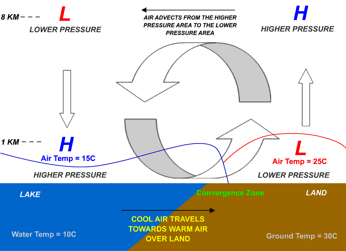
This is the moderating effect large bodies of water have on land close to them. Water is slow to heat up and cool down, making winters warmer and summers cooler on land close to water. Oceans have bigger effects than seas, large lakes have less again. Ireland, for example, benefits from this effect.
Continental Effect
The opposite of the maritime effect, this is the effect large land masses have on-air movements. The continental effect can cause extreme fluctuations in weather, resulting in very hot summers and very cold winters. Central Europe and central North America show the effects of this.
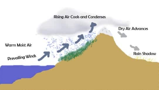
Rain Shadow
Just as a regular shadow indicates the absence of light, a rain shadow indicates the absence of rain. When a rain cloud is lifted by wind over a mountain, the rain is dropped either on the ascending side or when it passes over the mountain top and is dropped on the other side. The side that gets no rain is in the rain shadow.
Microclimates
Imagine microclimates as pockets of localized weather within a regional climate. Thanks to microclimates, plants get shelter from cold winds, more rainfall than they might elsewhere, or added exposure within valleys that trap the sun, for example. This factor allows for warmer-weather crops to flourish in areas they couldn’t normally grow. Additionally, microclimates can extend growing periods beyond what the local climate typically allows.
Some factors that influence microclimates are: aspect, slope, thermal mass, evaporation and condensation, humidity, windbreaks, and sun traps.
Major Landscape Profiles
Arid: (Dry Or Desert)
These landscapes are formed by strong winds and floods and are angular in profile. Dams are not appropriate here and water should not be stored in shallow ponds or embankments, as the evaporation rate is too high.
Small ponds should be shaded and nutrients should be captured using gabions (caged rock banks).
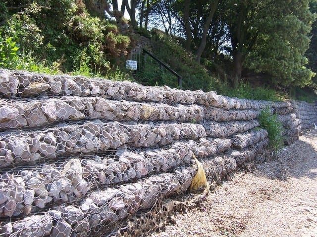 Figure 1 – Gabions
In arid climates, where soil erosion is the biggest danger to your enterprise, every effort should be made to capture wind-borne nutrients and to slow, stop, and sink water into the ground. Cover crops are one way to fight against erosion, another is to try to re-collect the soil before it flies away, taking fertilizer and seeds with it.
Wind-borne nutrients generally refer to the valuable topsoil that becomes airborne. This is where the majority of nutrients exist, so you want to protect your topsoil at all costs. Wind-borne nutrients are collected by windbreaks, like tree or hedgerows, where the slowing of the wind causes airborne soil to be deposited. Other forms of windbreaks can be man-made structures like walls and solid fences. Plus, your nutrient-breaks will collect topsoil from elsewhere, too, so you can capitalize on your neighbors’ gardens/farms. These deposits are often great sources of free nutrients for a farm—soil and fertilizer you don’t need to grow or buy.
As you become more familiar with these phenomena, you may start to notice piles of topsoil forming in front of trees and fence posts. To buy topsoil and truck it in can be very expensive, so take advantage of soil wherever you can find it.
Humid: (Wet; Either Tropical, Subtropical, Or Temperate Climates)
Characterized by rounded hills and mountains. Here swales and water catchments (dams and ponds) are dug to maximize water retention and production.
Minor Landscape Profiles
Volcanos
Characterized by steep slopes with a fertile ring of land at the base created by lava deposits. High ash contents and alkaline soils are typical.
Islands
Islands are often classified as high and low. High islands are created by volcanic activity. Low islands are formed from sedimentation or the uplifting of coral reefs (often formed on sunken volcanos).
A high island is often half arid and half humid due to rain shadow effects.
Sand or coral islands are at sea level and generally flat, with a freshwater “lens” at the center. This delicate source of fresh water must be carefully managed, as over pumping it will draw saltwater in and salify it, making it useless for irrigation or drinking. Without mountains to cause rain, what rainfall does occur must be stored in water tanks.
Windbreaks are necessary on islands to mitigate the effects of strong coastal winds. Dry composting toilets or similar eco-friendly waste disposal systems are recommended to prevent water table pollution.
Pit gardens can be dug down into the sand close to the water table to allow self-irrigating crop beds. To do this, you fill the dug hole with mulch and other organic material and fill the pit and rim with seedlings for a highly productive growing system.
Flatlands
Flatland presents some hurdles, but all can be overcome. The first is little gravity fall for water distribution, and the second is strong, unmitigated winds.
By digging swales below ground level and mounding up the excess earth onto the swale mounts, water can be captured and kept on the land for much longer.
When building dams, you are left with excess material that can be used to create embankments to shelter your home and vegetable gardens from strong winds if needed.
You might also position a dam to reflect light towards your home and garden, thereby increasing heat in winter. Shelter your home from any winds, as well, and you’ll have positioned yourself to take full advantage of the minimal resources available on flat terrain.
Wetlands
Wetlands are excellent for aquaculture but can be challenging for crop production.
Originating in ancient Mexico, chinampas are a Mesoamerican agricultural strategy in which small, rectangular areas of fertile land grow crops on shallow lake beds. Chinampas are ideally suited for a wetland landscape profile and are created by digging into the swampy soil and piling the material up in banks, creating canals surrounded by high fertile ground ideal for crop production.
 Figure 2 – Chinampa
Use the canals to farm fish and crustaceans—even raise ducks. This method produces one of the highest yields per unit of space achievable in agriculture.
Estuaries
Estuaries occur where rivers meet the sea and are subject to tidal flow traps. Use high-tide ponds for catching or raising fish, and harvest the nutrient-rich grasses and reeds that grow here to use as fertilizer on land.